


Footpath Route Planner
4.6282.00 Reviews
App Specs
- Version
- 2.4.0
- Updated On
- License
- Free
- Downloads
- 1,000,000+
- Developer
- Half Mile Labs LLC
- Categories
- Maps & Navigation
- Platform
- Android, iOS
Screenshots
 Analysis by AppCompare
I judge route-planning apps by whether they help me make a sensible plan before I leave, not just display a line on a map. Footpath Route Planner has a particularly approachable idea at its core: sketch the way you want to go, refine it on the map, and use GPS to follow along. That makes it appealing for walks and rides where choosing the route is part of the fun, though it is not a substitute for checking conditions or using sound judgment outdoors.
A planner built around choosing your own way
Footpath is a free maps and navigation app from Half Mile Labs LLC. It has a 4.6 average from around 8,500 ratings, and more than a million installs. The app is rated for Everyone, and its current version is 2.3.2. Those figures suggest it has found a sizeable audience, but the more useful question is whether its planning style fits how you like to get around.
The distinction I find most important is that Footpath starts with a route idea rather than simply asking for a destination. That suits someone who wants to trace a riverside path, connect several streets into a bike loop, or sketch a hike around a landmark. A conventional navigation app is often quicker when all you need is the fastest way from A to B. Footpath makes more sense when you care about the shape of the journey.
When drawing a route is genuinely useful
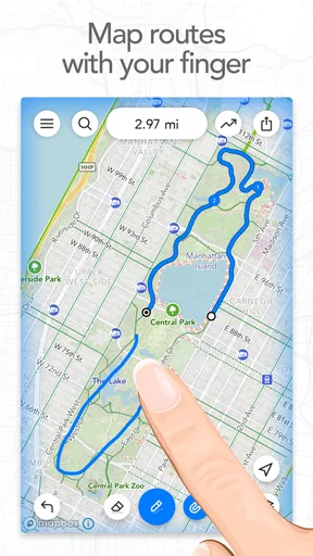
Finger-drawing is more than a novelty if you already have a rough route in mind. I can picture using it to plan a weekend walk that follows a greenway for a while, turns through a neighborhood, then returns on a different street. Instead of searching for every segment in sequence, I can sketch the broad outline and inspect the route the app forms. That lowers the effort of experimenting with alternatives.
There is a practical trade-off: a drawn line expresses what you want, not necessarily what is passable or suitable. Snapping it to mapped roads or trails can make the plan more legible, but I would still inspect unfamiliar sections rather than assume a path is open, public, or comfortable. For a route near private land, a seasonal closure, or a rough trail, local signs and current conditions matter more than a tidy map line.
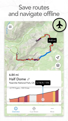
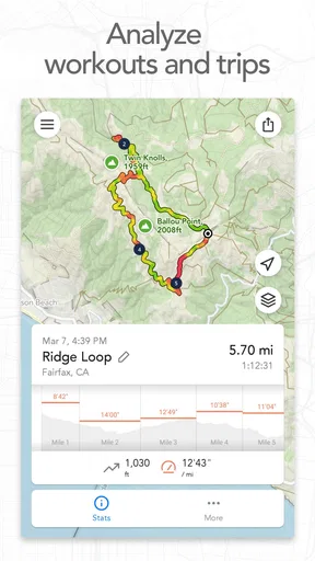
The elevation graph is useful before a walk or ride because distance alone can hide a demanding climb. I would use it to compare two otherwise similar loops, or to decide whether a route is realistic for a companion who prefers gentler terrain. A graph is still a planning aid, not a promise about trail conditions: loose surfaces, weather, and fatigue can change how hard a route feels.
Navigation and offline preparation
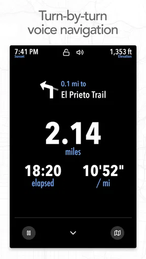
Following a planned route with GPS and voice guidance can reduce the need to keep checking the screen. That is especially welcome while cycling, when stopping to inspect a phone is inconvenient, or on a walk where I would rather pay attention to the surroundings. Still, I would treat spoken directions as prompts, not commands. If a turn sounds wrong or the path on the ground does not match the plan, it is sensible to stop and check.
Worth Reading Before You Choose

EA SPORTS FC Mobile 26 Is a Bigger Football Game, but It Takes Time

Flipboard Shows What News Apps Must Do Beyond the Feed

Switching to Android Auto Means Rethinking Your Driving Routine

Google Calendar Makes a Crowded Week Easier to Manage

Ludo King Makes the Most of the Minutes Between Plans

Baby Panda World Brings Quick Play to Modern Phones, but Its Game Library Feels Busy
Offline access is most valuable when it is prepared before service disappears. I would save the route and make sure the relevant map is available while I still have a connection, then check that the phone has enough battery for the outing. A saved map can help when mobile coverage drops, but it does not remove the need to carry a charged phone or have a backup plan on a remote trip.
For an everyday example, imagine planning a Saturday ride from home that avoids a busy road and returns by a quieter route. I would sketch the loop, look over the mapped sections, check the elevation, and save what I need before heading out. If the route depends on one uncertain connector, I would identify a nearby alternative in advance instead of relying on a last-minute search at the roadside.
Who will get the most from it
I think Footpath is best for walkers, hikers, and cyclists who enjoy shaping their own routes and want a straightforward way to turn an idea into something they can follow. It can also help when organizing a group outing: a planned route gives beginners a clearer sense of where they are going, while sharing makes it easier to pass that plan along. If your usual trip is a familiar commute or a simple drive to a known address, a standard navigation app may be faster and less work.
It is also worth separating route design from route discovery. If you want a steady stream of curated trail recommendations or highly detailed local reports, a dedicated outdoor community or trail guide may be a better starting point. Footpath’s appeal is the hands-on planning process; its usefulness depends in part on the map information available in the area you intend to explore.
Limits worth considering before a trip
Coverage can be uneven, particularly in remote places where mapped trail detail is sparse. That weakness matters most when a route relies on small paths or junctions that are difficult to verify on the ground. I would not make an unfamiliar, remote outing depend on this app alone. Check the route against another reliable source where possible, and keep a practical alternative in mind.
The app is free to start, with in-app purchases ranging from $1.99 to $23.49 per item. That makes it reasonable to try the planning workflow before deciding whether paid options are worthwhile for your habits. A casual user who only sketches an occasional local walk may be content without spending; someone who plans routes often should weigh the cost against the features they actually use rather than assume an upgrade is essential.
There is a small but important planning habit that can prevent frustration: inspect the route at a closer map scale around crossings, trail junctions, and places where the line changes direction. A broad view is good for judging the overall loop, but it can conceal a confusing turn. I would also avoid making a route so ambitious that there is no room to adjust it; a shorter option or turnaround point can make a plan more comfortable for a mixed-ability group.
How it fits into an outdoor toolkit
Compared with familiar turn-by-turn navigation, Footpath gives more attention to drawing and shaping a route than to finding the quickest point-to-point journey. Compared with specialist trail resources, it offers a more direct way to sketch a personal plan, but sparse mapping can limit confidence in less-traveled areas. I would use it alongside, rather than instead of, local knowledge when the route is unfamiliar or the consequences of a wrong turn are serious.
First impressions
The first thing I noticed upon downloading Footpath Route Planner was its clean and intuitive interface. It’s easy on the eyes and simple to navigate, which was a relief after struggling with clunky apps in the past. You know that feeling when you open an app and everything just feels right? That’s what happened here.
Setting up was a breeze. No lengthy sign-ups or unnecessary permissions, just straight to the point. I was able to dive into planning my first route within minutes. And let me tell you, it was fun!
Mapping Out the Perfect Route
What sets this app apart is its powerful mapping features. You can draw your route with your finger, which is oddly satisfying. It’s a bit like doodling, but with a purpose. The app then snaps your finger-drawn path to the nearest roads or trails, making it super accurate.
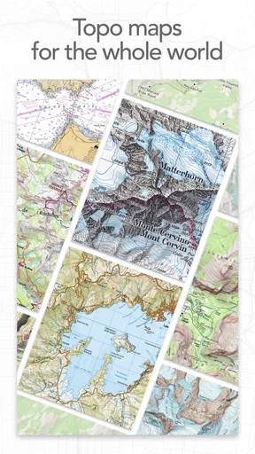
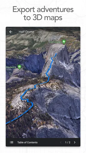
One of my favorite features is the ability to switch between different map types. Whether I’m in the mood for a satellite view or a simple street map, there are plenty of choices. Plus, the elevation graph is a lifesaver. It’s great to know what kind of terrain you're dealing with before lacing up those hiking boots.
Navigation Made Simple
Once your route is planned, navigating with Footpath is a joy. The turn-by-turn voice navigation is clear and won’t leave you guessing. It’s like having a hiking buddy who knows where they’re going (and you don’t have to share your snacks with them).
There’s also an offline mode. For those times when you’re deep in the woods with no signal, you can still access your saved maps. It’s peace of mind knowing you won’t get lost, even if your phone decides to go MIA on the cell service.
Sharing and Syncing
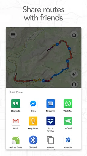
For the social butterflies out there, the app allows you to share your routes with friends. You can sync it with other devices too, so you can start planning on your tablet and hit the trail with your phone.
I've shared routes with friends who are just starting out, and they’ve appreciated the guidance. It’s a great way to introduce someone to hiking without overwhelming them.
Room for Improvement
No app is perfect, and Footpath has a few areas that could use some tweaking. While it covers many regions, there are some remote areas where trail data is sparse. I found this out the hard way on a trip to the middle of nowhere.
Also, while the free version is robust, some features are locked behind a paywall. The premium upgrade is worth it if you’re a serious hiker, but casual users might find the free version adequate.
Final Thoughts
Overall, Footpath Route Planner is an impressive tool for anyone who loves the outdoors. It’s become my go-to for planning hikes and bike rides. The app is reliable, easy to use, and packed with useful features that make exploring new trails a breeze.
If you’re tired of getting lost on your adventures and want a trusty guide, give Footpath a try. It might just be the perfect companion for your next outdoor excursion. Happy trails!
Pros
- User-friendly interface with intuitive navigation.
- Accurate route mapping for various activities.
- Offline maps available for remote areas.
- Customizable routes to fit personal preferences.
- Seamless integration with fitness trackers.
Cons
- Limited free features
- subscription required.
- Occasional GPS inaccuracies in dense areas.
- Battery consumption can be high on long routes.
- Lack of social sharing features for routes.
- Not available in all regions worldwide.
FAQs for Footpath Route Planner
What is Footpath Route Planner, and how does it work?
Footpath Route Planner is a navigation app designed to help users create and explore routes for hiking, biking, running, or walking. By simply drawing your path on the map, the app calculates the best route based on your preferences. It offers detailed maps, elevation profiles, and the ability to save and share routes with others.
Can I use Footpath Route Planner offline?
Yes, Footpath Route Planner offers offline capabilities. Users can download maps and planned routes to access them without an internet connection. This feature is particularly useful for outdoor adventures in remote areas where cellular service might be unreliable.
Is Footpath Route Planner free to use?
Footpath Route Planner offers both a free version and a premium subscription. The free version includes basic features like route planning and map browsing, while the premium version unlocks advanced features such as offline maps, route editing, and more detailed elevation profiles.
How accurate are the elevation profiles in Footpath Route Planner?
The elevation profiles provided by Footpath Route Planner are generally accurate and are calculated using topographic data. However, users should be aware that there may be slight discrepancies due to variations in data sources and GPS accuracy. It's always a good idea to double-check critical aspects of your route.
What devices are compatible with Footpath Route Planner?
Footpath Route Planner is available for both Android and iOS devices. It requires a device running Android 5.0 or later, or iOS 12.0 or later. The app is optimized for smartphones and tablets, providing a user-friendly interface tailored for each platform.


